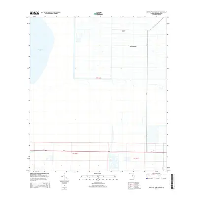
2015 Map of North of Gum Slough
USGS Topo · Published 2015About this map
Fellsmere and its surrounding agricultural and aquatic landscape define this 2015 survey of Indian River County. The map is dominated by the vast grid of irrigation and drainage canals characteristic of this region's citrus and farming heritage, stretching eastward from the shores of Blue Cypress Lake. This network provides a clear view of the water management infrastructure that has historically supported local industry. Civil aviation is represented by the Fellsmere Airport, situated just north of the residential blocks. The southern portion of the quadrangle is bisected by the prominent transit corridor of SR-60, while CR-512 provides a primary north-south artery through the developed portions of the township. This modern edition captures the organized layout of the community as it interfaces with the marshlands and water bodies of the Florida interior.
Find a feature on this map
9 named features on this map. Tap any name to fly to it.
Don’t see what you’re looking for? This feature index may not catch every label — zoom into the map to look around manually.
Map Details
Editions of this 2015 North of Gum Slough Map
This is the sole edition of this map. No revisions or reprints were ever made.
Other maps of this area

1949 · Fellsmere
USGS Topo · 1:24,000

1951 · Fellsmere
USGS Topo · 1:24,000

1953 · Fellsmere SW
USGS Topo · 1:24,000

1953 · Fort Drum
USGS Topo · 1:24,000

1953 · Fellsmere 4 SE
USGS Topo · 1:24,000

1953 · Fort Drum NE
USGS Topo · 1:24,000

1953 · Fellsmere 4 SW
USGS Topo · 1:24,000

1953 · Kenansville SE
USGS Topo · 1:24,000

1953 · Fellsmere 4 NW
USGS Topo · 1:24,000
1953 · Fellsmere 4 NE
USGS Topo · 1:24,000