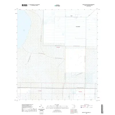
2021 Map of North of Gum Slough
USGS Topo · Published 2021About this map
Fellsmere and its surrounding wetlands are the central focus of this 2021 study, revealing the managed landscape of Indian River County. The northern portion of the map is dominated by the organized grid of the settlement, including the Fellsmere Airport, while the western edge is defined by the expansive waters of Blue Cypress Lake. This transition from municipal planning to wild conservation land is bridged by an extensive network of trails, such as the Blue Cypress Conservation Area Trl and the Fort Drum Marsh Conservation Area Trl. The map illustrates how human infrastructure like Co Rd 512 and 79th St interacts with the Florida marshland. For researchers, the clearly delineated township boundaries including t30s r36e and t33s r37e offer precise geographic context for land use and conservation boundaries in this section of the state.
Find a feature on this map
12 named features on this map. Tap any name to fly to it.
Don’t see what you’re looking for? This feature index may not catch every label — zoom into the map to look around manually.
Map Details
Editions of this 2021 North of Gum Slough Map
This is the sole edition of this map. No revisions or reprints were ever made.
Other maps of this area

1949 · Fellsmere
USGS Topo · 1:24,000

1951 · Fellsmere
USGS Topo · 1:24,000

1953 · Fellsmere SW
USGS Topo · 1:24,000

1953 · Fort Drum
USGS Topo · 1:24,000

1953 · Fellsmere 4 SE
USGS Topo · 1:24,000

1953 · Fort Drum NE
USGS Topo · 1:24,000

1953 · Fellsmere 4 SW
USGS Topo · 1:24,000

1953 · Kenansville SE
USGS Topo · 1:24,000

1953 · Fellsmere 4 NW
USGS Topo · 1:24,000
1953 · Fellsmere 4 NE
USGS Topo · 1:24,000