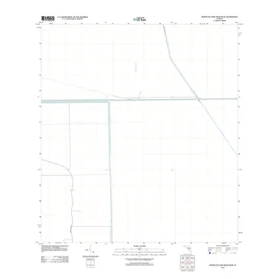
2012 Map of North of Lone Palm Head
USGS Topo · Published 2012About this map
The Miami Canal serves as the primary water management feature through this section of the Florida Everglades, reflecting the massive engineering efforts required to regulate the region's hydrology. This survey illustrates the rigid, geometric pattern of the landscape, where water control structures like Levee 4 dictate the local geography. Human activity is confined primarily to access routes such as Miami Canal Rd and Lemon Grove Rd, which border the vast conservation areas. The intersection of these levees and canals highlights the late 20th-century reliance on artificial drainage systems to manage the unique wetland environment of Broward County.
Find a feature on this map
4 named features on this map. Tap any name to fly to it.
Don’t see what you’re looking for? This feature index may not catch every label — zoom into the map to look around manually.
Map Details
Editions of this 2012 North of Lone Palm Head Map
This is the sole edition of this map. No revisions or reprints were ever made.
Other maps of this area

1956 · West Palm Beach
USGS Topo · 1:250,000

1957 · West Palm Beach
USGS Topo · 1:250,000

1958 · West Palm Beach
USGS Topo · 1:250,000

1973 · Everglades 4 NW
USGS Topo · 1:24,000

1973 · Everglades 3 NE
USGS Topo · 1:24,000

1974 · Everglades 1 SW
USGS Topo · 1:24,000

1974 · Everglades 2 SW
USGS Topo · 1:24,000

1974 · Everglades 2 SE
USGS Topo · 1:24,000

1974 · Everglades 1 NW
USGS Topo · 1:24,000
1974 · Everglades 2 NW
USGS Topo · 1:24,000