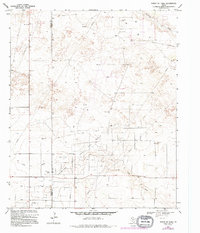
1969 Map of North of Tokio
USGS Topo · Published 1995About this map
The Prentice Gas Field dominates this West Texas landscape along the border of Yoakum and Terry counties. This late-1960s survey illustrates an economy built entirely on sub-surface resources, with an extensive network of pipelines, oil wells, and a dedicated Refinery. The natural terrain is defined by the ephemeral courses of Sulphur Draw and Lost Draw, which cut through the high plains. Industrial operations are supported by numerous gravel pits and borrow pits scattered throughout the region. A lone Radio Tower stands as a navigational landmark in an area otherwise characterized by technical infrastructure and the sparse grid of ranch roads and section lines typical of the Llano Estacado during the post-war energy boom.
Find a feature on this map
13 named features on this map. Tap any name to fly to it.
Don’t see what you’re looking for? This feature index may not catch every label — zoom into the map to look around manually.
Map Details
Editions of this 1969 North of Tokio Map
Other maps of this area

1954 · Brownfield
USGS Topo · 1:250,000

1958 · Brownfield
USGS Topo · 1:250,000

1962 · Brownfield
USGS Topo · 1:250,000

1965 · Sundown
USGS Topo · 1:24,000

1965 · Plains 1 NE
USGS Topo · 1:24,000

1969 · Gomez
USGS Topo · 1:24,000

1969 · Plains 1 SE
USGS Topo · 1:24,000

1969 · Pool
USGS Topo · 1:24,000

1970 · Plains 1 SW
USGS Topo · 1:24,000

1970 · Tokio
USGS Topo · 1:24,000