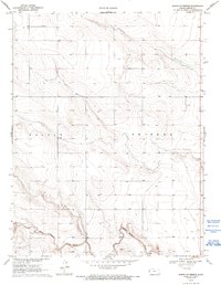
1970 Map of North of Tribune
USGS Topo · Published 1993About this map
White Woman Creek winds through the southern reaches of this High Plains landscape, defining the primary drainage for the area north of the Greeley County seat. In 1970, the land remains largely open range and agricultural, segmented by the township boundaries of Colony and Tribune. The presence of numerous Wells across the uplands indicates the vital importance of groundwater for sustaining the farmsteads and ranching operations of this semi-arid region. Near the creek bed, localized industrial activity is visible through labels for a Sandpit, a Gravel Pit, and the Graves site, highlighting the extraction of stream-borne deposits. This survey preserves a quiet moment in Western Kansas history, showing a rural infrastructure of section-line roads and scattered water sources before further modern development reached this part of the state.
Find a feature on this map
8 named features on this map. Tap any name to fly to it.
Don’t see what you’re looking for? This feature index may not catch every label — zoom into the map to look around manually.
Map Details
Editions of this 1970 North of Tribune Map
2 editions found
Other maps of this area

1955 · Scott City
USGS Topo · 1:250,000

1958 · Scott City
USGS Topo · 1:250,000

1968 · Sharon Springs 3 NE
USGS Topo · 1:24,000

1968 · Sharon Springs 4 NW
USGS Topo · 1:24,000

1968 · Sharon Springs 3 NW
USGS Topo · 1:24,000

1970 · Sharon Springs 3 SE
USGS Topo · 1:24,000

1970 · Sharon Springs 4 SW
USGS Topo · 1:24,000
1970 · Sharon Springs 3 SW
USGS Topo · 1:24,000

1970 · Selkirk NW
USGS Topo · 1:24,000
1970 · Tribune NW
USGS Topo · 1:24,000