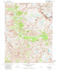
1982 Map of North Palisade
USGS Topo · Published 1983About this map
Kings Canyon National Park dominates this 1982 survey, capturing the high-elevation wilderness along the border of the Inyo National Forest. The map documents the intricate glacial geography of the Sierra Nevada, most notably the Palisade Glacier situated beneath the towering summits of North Palisade and Thunderbolt Peak. This landscape is defined by the steep descent of the Kings River drainage, where the Middle Fork flows through Le Conte Canyon past the Le Conte Ranger Station. Significant meadows such as Grouse Meadow and Big Pete Meadow offer brief breaks in the granite terrain. The route of the Pacific Crest National Scenic Trail is clearly delineated as it traverses the Inyo National Forest and Wilderness Boundary at Bishop Pass, providing a detailed record of the trail's path before modern variations.
Find a feature on this map
62 named features on this map. Tap any name to fly to it.
Don’t see what you’re looking for? This feature index may not catch every label — zoom into the map to look around manually.
Map Details
Editions of this 1982 North Palisade Map
3 editions found
Other maps of this area

1903 · Tehipite
USGS Topo · 1:125,000

1905 · Tehipite
USGS Topo · 1:125,000

1907 · Mt. Whitney
USGS Topo · 1:125,000

1912 · Mt. Goddard
USGS Topo · 1:125,000

1913 · Bishop
USGS Topo · 1:125,000

1919 · Mt. Whitney
USGS Topo · 1:125,000

1937 · Mt. Whitney
USGS Topo · 1:125,000

1947 · Mariposa
USGS Topo · 1:250,000

1948 · Fresno
USGS Topo · 1:250,000

1948 · Mariposa
USGS Topo · 1:250,000