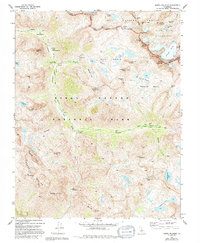
1982 Map of North Palisade
USGS Topo · Published 1994About this map
North Palisade dominates this high-altitude landscape where the boundaries of Kings Canyon National Park, Inyo National Forest, and the John Muir Wilderness meet. The terrain is defined by the massive Palisade Glacier and the sawtooth peaks of the Inconsolable Range, creating a complex network of alpine basins such as Dusy Basin and Palisade Basin. The convergence of the John Muir Trail and the Pacific Crest National Scenic Trail near Le Conte Ranger Station highlights the importance of this corridor for high-country travel during the late twentieth century.
Find a feature on this map
61 named features on this map. Tap any name to fly to it.
Don’t see what you’re looking for? This feature index may not catch every label — zoom into the map to look around manually.
Map Details
Editions of this 1982 North Palisade Map
3 editions found
Other maps of this area

1903 · Tehipite
USGS Topo · 1:125,000

1905 · Tehipite
USGS Topo · 1:125,000

1907 · Mt. Whitney
USGS Topo · 1:125,000

1912 · Mt. Goddard
USGS Topo · 1:125,000

1913 · Bishop
USGS Topo · 1:125,000

1919 · Mt. Whitney
USGS Topo · 1:125,000

1937 · Mt. Whitney
USGS Topo · 1:125,000

1947 · Mariposa
USGS Topo · 1:250,000

1948 · Fresno
USGS Topo · 1:250,000

1948 · Mariposa
USGS Topo · 1:250,000