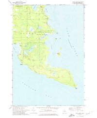
1971 Map of North Point
USGS Topo · Published 1974About this map
Thunder Bay River State Forest dominates this coastal landscape along the shores of Lake Huron in the early 1970s. The map illustrates a peninsula defined by complex water bodies, including the aptly named Misery Bay and the winding reaches of Elbow Lake. This area of Alpena County shows a landscape shaped by both nature and industry, with numerous Gravel Pits and Gravel Pits scattered near Indian Road and North Point Road.
Find a feature on this map
24 named features on this map. Tap any name to fly to it.
Don’t see what you’re looking for? This feature index may not catch every label — zoom into the map to look around manually.
Map Details
Editions of this 1971 North Point Map
2 editions found
Other maps of this area

1954 · Tawas City
USGS Topo · 1:250,000

1954 · Alpena
USGS Topo · 1:250,000

1957 · Alpena
USGS Topo · 1:250,000

1958 · Alpena
USGS Topo · 1:250,000

1958 · Tawas City
USGS Topo · 1:250,000

1969 · Alpena
USGS Topo · 1:250,000

1971 · Alpena
USGS Topo · 1:24,000
1971 · Thunder Bay Island
USGS Topo · 1:24,000

1971 · Middle Island
USGS Topo · 1:24,000

1971 · North Point
USGS Topo · 1:24,000