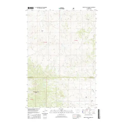
2017 Map of North Stacey School
USGS Topo · Published 2017About this map
North Stacey School and its nearby cemetery anchor the southeastern corner of this map on the border of Powder River and Custer counties. This rural landscape is defined by the high, broken terrain of the Custer National Forest, where drainages like Mullins Coulee and Starvation Cr carve through the high plains. The area is marked by vital water sources in an otherwise arid environment, including Bathtub Spring, Red Shale Spring, and Viscom Mountain Spring. Significant landmarks such as Castle Rock rise above the complex network of creeks, including Foster Cr and Lay Cr. The road network is sparse, consisting of routes like Foster Creek Rd and Horkan Creek Rd, reflecting the remote ranching and forest-land character of this Montana frontier.
Find a feature on this map
25 named features on this map. Tap any name to fly to it.
Don’t see what you’re looking for? This feature index may not catch every label — zoom into the map to look around manually.
Map Details
Editions of this 2017 North Stacey School Map
This is the sole edition of this map. No revisions or reprints were ever made.
Other maps of this area

1954 · Hardin
USGS Topo · 1:250,000

1954 · Ekalaka
USGS Topo · 1:250,000

1956 · Ekalaka
USGS Topo · 1:250,000

1957 · Hardin
USGS Topo · 1:250,000

1958 · Ekalaka
USGS Topo · 1:250,000

1958 · Hardin
USGS Topo · 1:250,000

1965 · Ekalaka
USGS Topo · 1:250,000
1966 · Stacey
USGS Topo · 1:24,000
1966 · Beaver Creek School
USGS Topo · 1:24,000
1966 · Elk Ridge
USGS Topo · 1:24,000