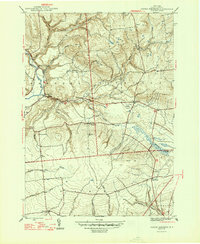
1947 Map of North Western
USGS Topo · Published 1947About this map
The Mohawk River and Black River define the western corridors of this Oneida County landscape, where agriculture and early settlements established deep roots in the post-war era. The survey captures a high-density of rural infrastructure, from the village of North Western to smaller hamlets like Frenchville and Big Brook. Genealogists will find significant value in the distribution of family and community burial grounds, including Penn Mtn Cem, Steuben Cem, and Nesbitt Cem, which are scattered among the prominent heights of Maple Mtn and Carmichael Hill. The presence of South Hill Sch and Gifford Hill Sch points to a decentralized educational system that served these upland farming communities. The southern reaches around East Floyd and Camroden show a network of creeks like Sixmile Creek and Cincinnati Creek feeding the local water system, providing a clear picture of the mid-century township boundaries between Western, Steuben, and Floyd.
Find a feature on this map
39 named features on this map. Tap any name to fly to it.
Don’t see what you’re looking for? This feature index may not catch every label — zoom into the map to look around manually.
Map Details
Editions of this 1947 North Western Map
2 editions found
Other maps of this area

1895 · Oriskany
USGS Topo · 1:62,500

1897 · Remsen
USGS Topo · 1:62,500

1898 · Utica
USGS Topo · 1:62,500

1898 · Oriskany
USGS Topo · 1:62,500

1900 · Utica
USGS Topo · 1:62,500

1900 · Remsen
USGS Topo · 1:62,500

1904 · Boonville
USGS Topo · 1:62,500
1945 · South Trenton
USGS Topo · 1:31,680

1945 · Boonville
USGS Topo · 1:24,000

1945 · Forestport
USGS Topo · 1:24,000