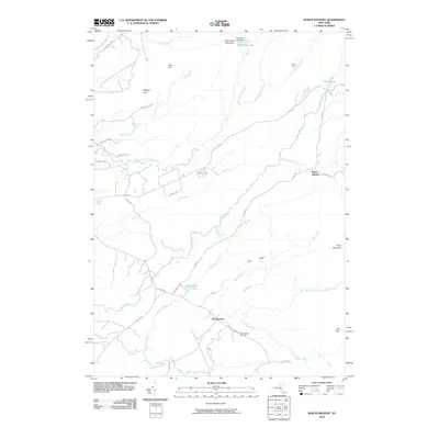
2010 Map of North Wilmurt
USGS Topo · Published 2010About this map
Wheelertown and North Wilmurt anchor this 2010 topographic record of the Adirondack foothills, where a complex network of forest roads and remote camps defines the landscape. The Black River meanders through the central terrain, joined by numerous tributaries including Muskrat Brook and Twin Lakes Stream. The southern portion of the quadrangle centers on the small settlement of Wheelertown, marked by the Wheelertown Cemetery and the intersection of Wheelertown Rd and Jim Rose Rd. To the north, the geography becomes more varied with elevations like Stone Dam Mountain and Finn Hill. Local history and land use are evidenced by named outposts such as Lyons Camp and Stone Dam Lake Camp near Stone Dam Lake, illustrating the area's long-standing connection to seasonal recreation and timber interests. Water features dominate the interior, from Maple Lake to the secluded Deep Lake along Pine Creek.
Find a feature on this map
45 named features on this map. Tap any name to fly to it.
Don’t see what you’re looking for? This feature index may not catch every label — zoom into the map to look around manually.
Map Details
Editions of this 2010 North Wilmurt Map
This is the sole edition of this map. No revisions or reprints were ever made.
Other maps of this area

1897 · Remsen
USGS Topo · 1:62,500

1900 · Remsen
USGS Topo · 1:62,500

1900 · Wilmurt
USGS Topo · 1:62,500

1901 · Old Forge
USGS Topo · 1:62,500

1902 · Wilmurt
USGS Topo · 1:62,500

1912 · Mc Keever
USGS Topo · 1:62,500

1945 · Forestport
USGS Topo · 1:24,000
1946 · Hinckley
USGS Topo · 1:25,000
1946 · Remsen
USGS Topo · 1:31,680
1946 · North Wilmurt
USGS Topo · 1:24,000