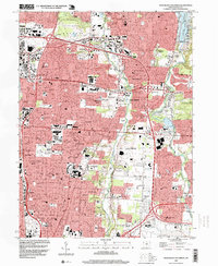
1995 Map of Northeast Columbus
USGS Topo · Published 1999About this map
Alum Creek and Big Walnut Creek define the suburban growth of northeast Franklin County in this mid-1990s record of development. The area is anchored by the northern expansion of Columbus and the established communities of Westerville and Gahanna. This landscape is notable for its substantial parklands and conservation efforts, featuring the sprawling Sharon Woods Metropolitan Park and Inniswood Gardens.
Find a feature on this map
73 named features on this map. Tap any name to fly to it.
Don’t see what you’re looking for? This feature index may not catch every label — zoom into the map to look around manually.
Map Details
Editions of this 1995 Northeast Columbus Map
This is the sole edition of this map. No revisions or reprints were ever made.
Other maps of this area

1901 · Dublin
USGS Topo · 1:62,500

1902 · Westerville
USGS Topo · 1:62,500

1903 · Dublin
USGS Topo · 1:62,500

1904 · Westerville
USGS Topo · 1:62,500

1923 · West Columbus
USGS Topo · 1:62,500

1925 · East Columbus
USGS Topo · 1:62,500

1925 · West Columbus
USGS Topo · 1:62,500

1943 · East Columbus
USGS Topo · 1:62,500

1947 · Columbus
USGS Topo · 1:250,000

1950 · Marion
USGS Topo · 1:250,000