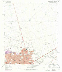
1965 Map of Northeast Midland
USGS Topo · Published 1975About this map
Midland expanded rapidly during the mid-1960s, a growth period marked by burgeoning residential neighborhoods and civic infrastructure. This survey captures the city’s northeastern frontier, where urban street grids like Wadley Ave and Neely Ave give way to the industrial and agricultural landscape of the Permian Basin. The transition is evident at Hogan Park and the nearby Midland Airpark, which serve as buffers between the city center and the sprawling oil fields and ranchlands of Martin and Midland counties.
Find a feature on this map
51 named features on this map. Tap any name to fly to it.
Don’t see what you’re looking for? This feature index may not catch every label — zoom into the map to look around manually.
Map Details
Editions of this 1965 Northeast Midland Map
2 editions found

Other maps of this area

1954 · Hobbs
USGS Topo · 1:250,000

1954 · Pecos
USGS Topo · 1:250,000

1954 · Big Spring
USGS Topo · 1:250,000

1954 · San Angelo
USGS Topo · 1:250,000

1957 · Pecos
USGS Topo · 1:250,000

1958 · San Angelo
USGS Topo · 1:250,000

1958 · Big Spring
USGS Topo · 1:250,000

1958 · Hobbs
USGS Topo · 1:250,000

1965 · San Angelo
USGS Topo · 1:250,000

1965 · Southeast Midland
USGS Topo · 1:24,000