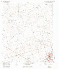
1966 Map of Northwest Midland
USGS Topo · Published 1985About this map
The expanding northern limits of Midland characterize this 1966 survey, revised in the mid-1970s to show the city's residential growth. The urban edge is defined by institutional and recreational landmarks including Lee High Sch, Rusk Sch, and the Episcopal Day Sch. Beyond the neighborhood streets of Neely Ave and Wadley Ave, the landscape shifts abruptly to an industrial and ranching periphery. This transition zone is marked by a network of energy infrastructure, where numerous Drill Holes and several segments of Pipeline reflect the region's petroleum dependency. To the northwest, the High Sky Girls Ranch sits in open country, while the natural drainage of Midland Draw cuts across the more developed eastern half of the sheet, providing a stark contrast between the grid of the city and the intermittent watercourses of the high plains.
Find a feature on this map
26 named features on this map. Tap any name to fly to it.
Don’t see what you’re looking for? This feature index may not catch every label — zoom into the map to look around manually.
Map Details
Editions of this 1966 Northwest Midland Map
3 editions found

Other maps of this area

1954 · Hobbs
USGS Topo · 1:250,000

1954 · Pecos
USGS Topo · 1:250,000

1957 · Pecos
USGS Topo · 1:250,000

1958 · Hobbs
USGS Topo · 1:250,000

1964 · Odessa NE
USGS Topo · 1:24,000

1965 · Southeast Midland
USGS Topo · 1:24,000

1965 · Southwest Midland
USGS Topo · 1:24,000

1965 · Northeast Midland
USGS Topo · 1:24,000

1966 · Mabee Ranch
USGS Topo · 1:24,000

1966 · North Curtis Ranch
USGS Topo · 1:24,000