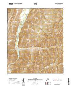
2017 Map of Norton Bay C-3 SW
USGS Topo · Published 2017About this map
Shaktoolik River meanders through the western portion of this 2017 survey, carving a path through the interior of the Seward Peninsula region. The landscape is defined by the significant elevations of the Nulato Hills, which dominate the eastern and central sections of the quadrangle. This map primarily documents the natural topography and drainage patterns of the area before they are altered by any significant human infrastructure. The absence of roads, settlements, or structures emphasizes the isolation of this corner of the Nome Census Area. For those interested in the environmental history of western Alaska, this document captures the precise contour of the river valley and the surrounding ridges within the t10s r9w and t11s r8w land divisions.
Find a feature on this map
6 named features on this map. Tap any name to fly to it.
Don’t see what you’re looking for? This feature index may not catch every label — zoom into the map to look around manually.
Map Details
Editions of this 2017 Norton Bay C-3 SW Map
This is the sole edition of this map. No revisions or reprints were ever made.
Other maps of this area

1948 · Norton Bay
USGS Topo · 1:250,000

1950 · Norton Bay B-4
USGS Topo · 1:63,360

1950 · Norton Bay B-3
USGS Topo · 1:63,360

1950 · Norton Bay C-3
USGS Topo · 1:63,360

1950 · Norton Bay C-4
USGS Topo · 1:63,360

1951 · Norton Bay
USGS Topo · 1:250,000

1955 · Norton Bay
USGS Topo · 1:250,000
2014 · Norton Bay C-4 NE
USGS Topo · 1:25,000
2017 · Norton Bay B-3 NW
USGS Topo · 1:25,000
2017 · Norton Bay C-3 NE
USGS Topo · 1:25,000