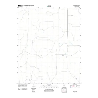
2010 Map of Norton
USGS Topo · Published 2010About this map
Puerto Creek and its various tributaries, including Barranca Creek and Dog Canyon Creek, carve a drainage network across this portion of Quay County. The landscape is defined by the transition from open range into the deeper relief of Puerto Canyon in the southeast. Human presence is scattered among small named points like Norton, Hodges, and Woodard, which are connected by a rigid grid of rural routes such as Quay Road 51 and Quay Road AE. The Puerto Cemetery serves as a significant landmark for genealogical research, situated centrally among the drainages. This survey captures the rural character of eastern New Mexico at the start of the 21st century, illustrating how modern road designations have been superimposed over a topography long shaped by seasonal watercourses.
Find a feature on this map
21 named features on this map. Tap any name to fly to it.
Don’t see what you’re looking for? This feature index may not catch every label — zoom into the map to look around manually.
Map Details
Editions of this 2010 Norton Map
This is the sole edition of this map. No revisions or reprints were ever made.
Other maps of this area

1930 · Tucumcari
USGS Topo · 1:125,000

1954 · Tucumcari
USGS Topo · 1:250,000

1954 · Clovis
USGS Topo · 1:250,000

1958 · Clovis
USGS Topo · 1:250,000

1958 · Tucumcari
USGS Topo · 1:250,000

1968 · Bulldog Mesa
USGS Topo · 1:24,000

1968 · Bedford Hill
USGS Topo · 1:24,000
1968 · Tucumcari SE
USGS Topo · 1:24,000

1971 · Ragland
USGS Topo · 1:24,000
1971 · Mesa Redonda
USGS Topo · 1:24,000