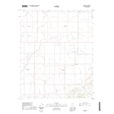
2023 Map of Norton
USGS Topo · Published 2023About this map
Norton anchors the northeastern corner of this Quay County landscape, where the high plains meet the dramatic drop-offs of the Pecos River basin. The terrain is defined by the sharp transition at The Caprock, a significant geological escarpment that separates the elevated plateau from the lower drainage areas. This area is characterized by a sparse, ranching-oriented road network including Quay Rd 51 and Quay Road AI, which navigate around the natural incisions of Barranca Creek and Puerto Creek. Evidence of early settlement and local genealogy can be found at the Puerto Cem, situated near the head of Puerto Canyon. The drainage pattern of Dog Canyon Creek and other intermittent streams illustrates the erosional forces that have shaped this portion of eastern New Mexico, creating a landscape of canyons and mesas that remain largely rural and open.
Find a feature on this map
19 named features on this map. Tap any name to fly to it.
Don’t see what you’re looking for? This feature index may not catch every label — zoom into the map to look around manually.
Map Details
Editions of this 2023 Norton Map
This is the sole edition of this map. No revisions or reprints were ever made.
Other maps of this area

1930 · Tucumcari
USGS Topo · 1:125,000

1954 · Tucumcari
USGS Topo · 1:250,000

1954 · Clovis
USGS Topo · 1:250,000

1958 · Clovis
USGS Topo · 1:250,000

1958 · Tucumcari
USGS Topo · 1:250,000

1968 · Bulldog Mesa
USGS Topo · 1:24,000

1968 · Bedford Hill
USGS Topo · 1:24,000
1968 · Tucumcari SE
USGS Topo · 1:24,000

1971 · Ragland
USGS Topo · 1:24,000
1971 · Mesa Redonda
USGS Topo · 1:24,000