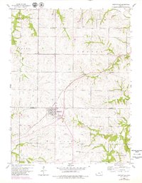
1960 Map of Nortonville
USGS Topo · Published 1979About this map
Nortonville stands as the primary hub of activity in this northern Kansas landscape, straddling the border between Atchison Co and Jefferson Co. The town is bisected by the Atchison Topeka and Santa Fe railroad, which enters from the north and curves sharply southwest toward the sewage disposal facilities. This transport artery underscores the area's agricultural reliance on rail transit during the mid-20th century, connecting local farms to wider markets.
Find a feature on this map
21 named features on this map. Tap any name to fly to it.
Don’t see what you’re looking for? This feature index may not catch every label — zoom into the map to look around manually.
Map Details
Editions of this 1960 Nortonville Map
3 editions found
Other maps of this area

1885 · Atchison
USGS Topo · 1:125,000

1886 · Oskaloosa
USGS Topo · 1:125,000

1888 · Oskaloosa
USGS Topo · 1:125,000

1888 · Atchison
USGS Topo · 1:125,000

1893 · Atchison
USGS Topo · 1:125,000

1894 · Oskaloosa
USGS Topo · 1:125,000

1926 · Atchison
USGS Topo · 1:62,500

1950 · Kansas City
USGS Topo · 1:250,000

1954 · Kansas City
USGS Topo · 1:250,000

1956 · Kansas City
USGS Topo · 1:250,000