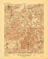
1912 Map of Nortonville
USGS Topo · Published 1945About this map
The junction of the Louisville and Nashville and Illinois Central railroads defines the corridor of Western Kentucky captured in this 1910 survey. Centered on the town of Nortonville, the map reveals a landscape heavily shaped by early 20th-century transportation and commerce, where the Madisonville and Greenville Road and several other thoroughfares connected rural outposts. Local trade is marked by several general stores, including Jordons Store, Sharbers Store, and Dukes Store.
Find a feature on this map
92 named features on this map. Tap any name to fly to it.
Don’t see what you’re looking for? This feature index may not catch every label — zoom into the map to look around manually.
Map Details
Editions of this 1912 Nortonville Map
3 editions found
Other maps of this area

1907 · Earlington
USGS Topo · 1:48,000

1909 · Dawson Springs
USGS Topo · 1:48,000

1909 · Earlington
USGS Topo · 1:62,500

1909 · Madisonville
USGS Topo · 1:62,500

1909 · Central City
USGS Topo · 1:62,500

1911 · Dawson Springs
USGS Topo · 1:62,500

1911 · Drakesboro
USGS Topo · 1:48,000

1912 · Nortonville
USGS Topo · 1:62,500

1913 · Drakesboro
USGS Topo · 1:62,500

1952 · Pleasant Green Hill
USGS Topo · 1:24,000