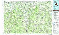
1986 Map of Norwich
USGS Topo · Published 1993About this map
The Chenango River valley and its surrounding hills define this landscape in the mid-1980s, serving as a corridor for both the Conrail line and N Y 12. In the northern reaches, Colgate University sits at the heart of the settlement pattern, while the region's diverse topography is marked by significant water management features like the Eaton Reservoir, DeRuyter Reservoir, and Bradley Brook Reservoir.
Find a feature on this map
288 named features on this map. Tap any name to fly to it.
Don’t see what you’re looking for? This feature index may not catch every label — zoom into the map to look around manually.
Map Details
Editions of this 1986 Norwich Map
2 editions found
Other maps of this area

1895 · Chittenango
USGS Topo · 1:62,500

1895 · Oriskany
USGS Topo · 1:62,500

1895 · Syracuse
USGS Topo · 1:62,500

1895 · Oneida
USGS Topo · 1:62,500

1897 · Cazenovia
USGS Topo · 1:62,500

1898 · Oneida
USGS Topo · 1:62,500

1898 · Syracuse
USGS Topo · 1:62,500

1898 · Chittenango
USGS Topo · 1:62,500

1898 · Utica
USGS Topo · 1:62,500

1898 · Oriskany
USGS Topo · 1:62,500