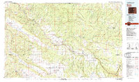
1983 Map of Nucla
USGS Topo · Published 1983About this map
Nucla and the San Miguel River corridor anchor this western Colorado study, revealing a landscape deeply marked by mid-century mining and high-desert agriculture. The map documents the intricate network of claims and extractors that defined the region’s economy, including the Sunrise Mine, Morning Glory Mine, and Bald Eagle Mines. Settlement patterns follow the river valleys and irrigation sources, from the isolated ranching communities in the Paradox Valley to the specialized milling town of Uravan and the smaller clusters at Redvale and Slick Rock.
Find a feature on this map
76 named features on this map. Tap any name to fly to it.
Don’t see what you’re looking for? This feature index may not catch every label — zoom into the map to look around manually.
Map Details
Editions of this 1983 Nucla Map
2 editions found
Other maps of this area

1885 · La Sal
USGS Topo · 1:250,000

1886 · Abajo
USGS Topo · 1:250,000

1892 · Abajo
USGS Topo · 1:250,000

1893 · Abajo
USGS Topo · 1:250,000

1897 · Telluride
USGS Topo · 1:62,500

1904 · Telluride
USGS Topo · 1:62,500

1909 · Montrose
USGS Topo · 1:125,000

1911 · Montrose
USGS Topo · 1:125,000

1916 · Paradox Valley
USGS Topo · 1:125,000

1922 · Paradox Valley
USGS Topo · 1:125,000