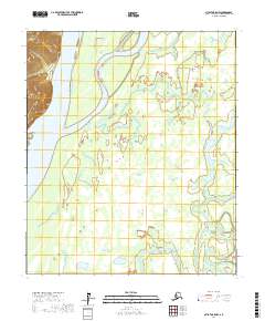
2017 Map of Nulato B-5 NW
USGS Topo · Published 2017About this map
The Yukon River dominates this landscape in the Yukon-Koyukuk Census Area, flowing past islands and into a complex network of wetlands and minor waterways. Large landmasses within the main channel, such as Sevenmile Island and Halfway Island, characterize the braiding nature of the river here. The river's historical importance as a transit corridor is evident in the surrounding terrain, where ancient bypasses and backwaters like Kaiyuh Slough weave through the interior. Toward the southeastern corner, the Khotol River meanders toward its confluence, illustrating the drainage patterns of the interior basin. This survey provides a high-resolution look at the shifting silt and water that define the region, showing how the primary river system influences the geography of the surrounding wilderness.
Find a feature on this map
11 named features on this map. Tap any name to fly to it.
Don’t see what you’re looking for? This feature index may not catch every label — zoom into the map to look around manually.
Map Details
Editions of this 2017 Nulato B-5 NW Map
This is the sole edition of this map. No revisions or reprints were ever made.
Other maps of this area

1945 · Nulato
USGS Topo · 1:250,000

1951 · Nulato
USGS Topo · 1:250,000

1952 · Nulato B-6
USGS Topo · 1:63,360

1952 · Nulato B-5
USGS Topo · 1:63,360

1952 · Nulato C-6
USGS Topo · 1:63,360

1952 · Nulato C-5
USGS Topo · 1:63,360

1952 · Nulato
USGS Topo · 1:250,000
1953 · Nulato C-5
USGS Topo · 1:63,360
1953 · Nulato C-6
USGS Topo · 1:63,360
1953 · Nulato B-5
USGS Topo · 1:63,360