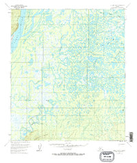
1953 Map of Nulato B-5
USGS Topo · Published 1967About this map
The Yukon River carves through the northwestern corner of this territory, dominated by a massive, intricate network of sloughs and meandering tributaries. The landscape is defined by the shifting waters of the Khotol River and the Tsurotulrna River, where countless lakes like Pike Lake and Skinny Fish Lake sit within a complex wetland system. This environment required specific infrastructure for communication, evidenced by the Abandoned Telegraph Line that runs along the western ridge line near Sevenmile Island.
Find a feature on this map
27 named features on this map. Tap any name to fly to it.
Don’t see what you’re looking for? This feature index may not catch every label — zoom into the map to look around manually.
Map Details
Editions of this 1953 Nulato B-5 Map
2 editions found
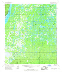
Other maps of this area

1945 · Nulato
USGS Topo · 1:250,000

1951 · Nulato
USGS Topo · 1:250,000

1952 · Nulato A-5
USGS Topo · 1:63,360

1952 · Nulato B-6
USGS Topo · 1:63,360

1952 · Nulato C-4
USGS Topo · 1:63,360

1952 · Nulato A-4
USGS Topo · 1:63,360

1952 · Nulato B-5
USGS Topo · 1:63,360

1952 · Nulato B-4
USGS Topo · 1:63,360

1952 · Nulato C-6
USGS Topo · 1:63,360

1952 · Nulato C-5
USGS Topo · 1:63,360