
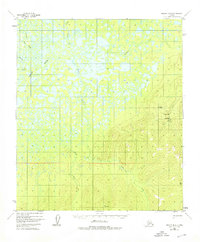
1952 Map of Nulato B-4
USGS Topo · Published 1957About this map
The Kaiyuh Mountains dominate the southeastern landscape of this interior Alaska territory, where the high ridges of VABM Eddy 2750 overlook a vast network of wetlands and waterways. Life in this remote corridor in the early 1950s was defined by isolated outposts like the Cabin and Camp Creek settlements. Access was strictly dictated by the seasons and the terrain, evidenced by an Airstrip and a specialized Airstrip (Skis Only) suited for winter landings. Resource extraction is noted at a solitary Mine located near the headwaters of Coyote Creek. The intricate drainage patterns of Eddy Creek and Bonanza Creek reveal a landscape where water and elevation determine the only viable locations for human activity and transport in the Alaskan wilderness.
Find a feature on this map
12 named features on this map. Tap any name to fly to it.
Don’t see what you’re looking for? This feature index may not catch every label — zoom into the map to look around manually.
Map Details
Editions of this 1952 Nulato B-4 Map
2 editions found
Other maps of this area

1945 · Nulato
USGS Topo · 1:250,000

1951 · Nulato
USGS Topo · 1:250,000

1952 · Nulato A-5
USGS Topo · 1:63,360

1952 · Nulato C-3
USGS Topo · 1:63,360

1952 · Nulato C-4
USGS Topo · 1:63,360

1952 · Nulato A-4
USGS Topo · 1:63,360

1952 · Nulato B-5
USGS Topo · 1:63,360

1952 · Nulato B-3
USGS Topo · 1:63,360

1952 · Nulato A-3
USGS Topo · 1:63,360

1952 · Nulato C-5
USGS Topo · 1:63,360