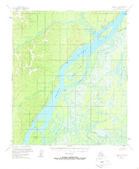
1953 Map of Nulato C-5
USGS Topo · Published 1962About this map
Nulato serves as the focal point of this mid-century survey, situated along the northern banks of the Yukon River. The landscape is defined by the complex hydrology of the river corridor, where the main channel is split by large landmasses like Nulato Island and Halfway Island, creating a labyrinth of secondary waterways including Mukluk Slough and Kaiyuh Slough. This intricate network of sloughs and rivers, such as the Soonkakat River, historically supported the local river-based economy and transit.
Find a feature on this map
21 named features on this map. Tap any name to fly to it.
Don’t see what you’re looking for? This feature index may not catch every label — zoom into the map to look around manually.
Map Details
Editions of this 1953 Nulato C-5 Map
2 editions found
Other maps of this area

1945 · Nulato
USGS Topo · 1:250,000

1951 · Nulato
USGS Topo · 1:250,000

1952 · Nulato B-6
USGS Topo · 1:63,360

1952 · Nulato D-5
USGS Topo · 1:63,360

1952 · Nulato C-4
USGS Topo · 1:63,360

1952 · Nulato B-5
USGS Topo · 1:63,360

1952 · Nulato D-4
USGS Topo · 1:63,360

1952 · Nulato B-4
USGS Topo · 1:63,360

1952 · Nulato C-6
USGS Topo · 1:63,360

1952 · Nulato C-5
USGS Topo · 1:63,360