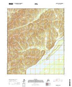
2017 Map of Nulato B-6 NE
USGS Topo · Published 2017About this map
The Yukon River dominates the southeastern quadrant of this terrain, its wide course punctuated by Sevenmile Island and Short Island. This 2017 survey reveals a landscape shaped by significant hydrographic features and prominent elevation points that serve as natural landmarks within the Yukon-Koyukuk region. To the north and west, the Ninemile River snakes through the high ground, while Notakok Mtn and Tamantaloi Hill provide distinct vertical relief. The map provides a precise look at the township and range divisions, such as t12s r1e, across a territory characterized by its lack of established roads or permanent settlements, emphasizing the role of major watercourses and named hills as the primary navigational aids in this part of the Alaska interior.
Find a feature on this map
12 named features on this map. Tap any name to fly to it.
Don’t see what you’re looking for? This feature index may not catch every label — zoom into the map to look around manually.
Map Details
Editions of this 2017 Nulato B-6 NE Map
This is the sole edition of this map. No revisions or reprints were ever made.
Other maps of this area

1945 · Nulato
USGS Topo · 1:250,000

1951 · Nulato
USGS Topo · 1:250,000

1952 · Nulato B-6
USGS Topo · 1:63,360

1952 · Nulato B-5
USGS Topo · 1:63,360

1952 · Nulato C-6
USGS Topo · 1:63,360

1952 · Nulato C-5
USGS Topo · 1:63,360

1952 · Nulato
USGS Topo · 1:250,000
1953 · Nulato C-5
USGS Topo · 1:63,360
1953 · Nulato C-6
USGS Topo · 1:63,360
1953 · Nulato B-5
USGS Topo · 1:63,360