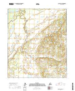
2017 Map of Nulato C-4 NW
USGS Topo · Published 2017About this map
Soonkakat River meanders across this interior landscape within the Yukon-Koyukuk Census Area, defining a vast wetland and riverine system. The terrain is characterized by a dense network of small ponds and intricate watercourses, notably where the river winds through the southern and central sections of the quadrangle. In the far northwestern corner, the Patsy Slough marks a distinct hydrological feature just north of the township boundary for t8s r4e. The mapping focuses on the natural hydrology of this roadless region, providing a detailed record of the shifting river channels and seasonal water bodies as they appeared during the 2017 survey.
Find a feature on this map
10 named features on this map. Tap any name to fly to it.
Don’t see what you’re looking for? This feature index may not catch every label — zoom into the map to look around manually.
Map Details
Editions of this 2017 Nulato C-4 NW Map
This is the sole edition of this map. No revisions or reprints were ever made.
Other maps of this area

1945 · Nulato
USGS Topo · 1:250,000

1951 · Nulato
USGS Topo · 1:250,000

1952 · Nulato D-5
USGS Topo · 1:63,360

1952 · Nulato C-4
USGS Topo · 1:63,360

1952 · Nulato D-4
USGS Topo · 1:63,360

1952 · Nulato C-5
USGS Topo · 1:63,360

1952 · Nulato
USGS Topo · 1:250,000
1953 · Nulato C-5
USGS Topo · 1:63,360
1953 · Nulato C-4
USGS Topo · 1:63,360

1964 · Nulato
USGS Topo · 1:250,000