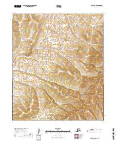
2019 Map of Nulato D-1 NW
USGS Topo · Published 2019About this map
Holtnakatna Cr winds through this expanse of the Yukon-Koyukuk region, its drainage system carving into the interior uplands of northwestern Alaska. The landscape shown here is defined by significant elevation changes, with numerous hills rising to distinct peaks separated by a dense network of smaller, unnamed tributaries. This 2019 data represents a wilderness largely untouched by permanent settlement or road infrastructure, emphasizing the raw physical geography of the t6s r12e and t6s r13e townships. The contour lines reveal a complex topography of ridgelines and valleys, illustrating the natural watercourses that define life in the Alaskan interior. For those studying the hydrology or land partitions of this region, the map provides a precise layout of the t7s r12e and t7s r13e boundaries within the Nulato quadrangle.
Find a feature on this map
5 named features on this map. Tap any name to fly to it.
Don’t see what you’re looking for? This feature index may not catch every label — zoom into the map to look around manually.
Map Details
Editions of this 2019 Nulato D-1 NW Map
This is the sole edition of this map. No revisions or reprints were ever made.
Other maps of this area

1945 · Nulato
USGS Topo · 1:250,000

1951 · Nulato
USGS Topo · 1:250,000

1951 · Kateel River
USGS Topo · 1:250,000

1952 · Nulato D-1
USGS Topo · 1:63,360

1952 · Kateel River A-2
USGS Topo · 1:63,360

1952 · Kateel River A-1
USGS Topo · 1:63,360

1952 · Nulato D-2
USGS Topo · 1:63,360

1952 · Nulato
USGS Topo · 1:250,000
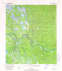
1954 · Nulato D-2
USGS Topo · 1:63,360

1955 · Kateel River
USGS Topo · 1:250,000