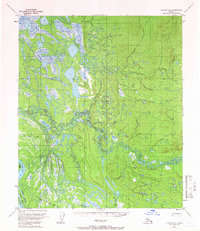
1954 Map of Nulato D-2
USGS Topo · Published 1965About this map
Galena Air Force Base stands as a prominent installation along the southern edge of this interior Alaskan landscape, positioned near the complex braided channels of the Yukon River. The topography is defined by the transition from the low-lying river valley to the upland terrain of the Nulato region. Water dominates the western half of the map, where the river splits around Serpentine Island and Lark Island, while Johnson Slough meanders through the wetlands. Further inland, the drainage systems of Bear Creek, Cub Bear Creek, and Beaver Creek carve through the hills. This 1954 survey, with minor revisions in 1965, illustrates the intersection of military infrastructure and the raw wilderness of the Yukon-Koyukuk area during the mid-century period.
Find a feature on this map
10 named features on this map. Tap any name to fly to it.
Don’t see what you’re looking for? This feature index may not catch every label — zoom into the map to look around manually.
Map Details
Editions of this 1954 Nulato D-2 Map
3 editions found
Other maps of this area

1945 · Nulato
USGS Topo · 1:250,000

1951 · Nulato
USGS Topo · 1:250,000

1951 · Kateel River
USGS Topo · 1:250,000

1952 · Nulato C-1
USGS Topo · 1:63,360

1952 · Nulato D-1
USGS Topo · 1:63,360

1952 · Kateel River A-2
USGS Topo · 1:63,360

1952 · Nulato D-3
USGS Topo · 1:63,360

1952 · Kateel River A-1
USGS Topo · 1:63,360

1952 · Nulato C-3
USGS Topo · 1:63,360

1952 · Nulato C-2
USGS Topo · 1:63,360