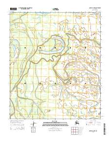
2015 Map of Nulato D-3 NW
USGS Topo · Published 2015About this map
The lowlands of central Alaska define this landscape in the western interior, dominated by a serpentine river system and a complex network of marshes. The topography is exceptionally flat, as shown by the widely spaced contours and the presence of numerous oxbow lakes and abandoned river channels that characterize the floodplain. This survey captures the natural state of the wilderness in the Yukon-Koyukuk region, revealing a terrain shaped entirely by water and seasonal change rather than human infrastructure.
Find a feature on this map
4 named features on this map. Tap any name to fly to it.
Don’t see what you’re looking for? This feature index may not catch every label — zoom into the map to look around manually.
Map Details
Editions of this 2015 Nulato D-3 NW Map
This is the sole edition of this map. No revisions or reprints were ever made.
Other maps of this area

1945 · Nulato
USGS Topo · 1:250,000

1951 · Nulato
USGS Topo · 1:250,000

1951 · Kateel River
USGS Topo · 1:250,000

1952 · Nulato D-3
USGS Topo · 1:63,360

1952 · Kateel River A-4
USGS Topo · 1:63,360

1952 · Nulato D-4
USGS Topo · 1:63,360

1952 · Kateel River A-3
USGS Topo · 1:63,360

1952 · Nulato
USGS Topo · 1:250,000
1954 · Nulato D-3
USGS Topo · 1:63,360

1955 · Kateel River
USGS Topo · 1:250,000