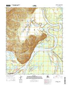
2015 Map of Nulato D-4 NE
USGS Topo · Published 2015About this map
Koyukuk sits at the base of Koyukuk Mtn, where the landscape transitions from the high ground of Mt Ella to the braided waters of the Koyukuk River. This 2015 survey illustrates the transportation infrastructure vital to this Interior Alaska settlement, including the Koyukuk Airport and a small network of local ways such as Spruce Street and Airport Road. The river dominates the eastern half of the map, carving a wide path around Koyukuk Island and receiving the flow of Hodegaden Cr. The map captures the intersection of the river-based economy and modern aviation, showing how the community is tied to the water while relying on the Koyukuk Road and Third Ridge Road for local transit between the town and its elevated surroundings.
Find a feature on this map
15 named features on this map. Tap any name to fly to it.
Don’t see what you’re looking for? This feature index may not catch every label — zoom into the map to look around manually.
Map Details
Editions of this 2015 Nulato D-4 NE Map
This is the sole edition of this map. No revisions or reprints were ever made.
Other maps of this area

1945 · Nulato
USGS Topo · 1:250,000

1951 · Nulato
USGS Topo · 1:250,000

1951 · Kateel River
USGS Topo · 1:250,000

1952 · Nulato D-3
USGS Topo · 1:63,360

1952 · Kateel River A-4
USGS Topo · 1:63,360

1952 · Nulato D-4
USGS Topo · 1:63,360

1952 · Kateel River A-3
USGS Topo · 1:63,360

1952 · Nulato
USGS Topo · 1:250,000
1954 · Nulato D-3
USGS Topo · 1:63,360

1955 · Kateel River
USGS Topo · 1:250,000