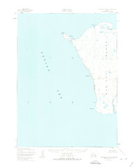
1952 Map of Nunivak Island A-7
USGS Topo · Published 1974About this map
Nunivak Island is depicted here along its westernmost edge, where the land meets the Bering Sea at the prominent headland of Cape Mohican. The map captures a landscape defined by seasonal subsistence patterns and coastal features, within the boundaries of the Nunivak National Wildlife Refuge. Traces of indigenous habitation and land use are evident in labels for seasonal sites like Ikookmiut (Summer Camp) and Mikisagimiut (Summer Camp), providing spatial context for traditional activities before the mid-century period. Along the shoreline, the topography transitions from the Sand and Boulder Beach to the steep elevations of Binakbak Bluff. Significant hydrological features such as the Dooksoak River and Dooksoak Lagoon dominate the southern portion of the sheet, while navigational markers like Ikook Pt and Nabangoyak Rock define the maritime approach to the island.
Find a feature on this map
16 named features on this map. Tap any name to fly to it.
Don’t see what you’re looking for? This feature index may not catch every label — zoom into the map to look around manually.
Map Details
Editions of this 1952 Nunivak Island A-7 Map
3 editions found
Other maps of this area

1951 · Cape Mendenhall
USGS Topo · 1:250,000

1951 · Nunivak Island
USGS Topo · 1:250,000

1952 · Nunivak Island A-7
USGS Topo · 1:63,360

1952 · Cape Mendenhall
USGS Topo · 1:250,000

1952 · Cape Mendenhall D-6
USGS Topo · 1:63,360

1952 · Nunivak Island A-6
USGS Topo · 1:63,360

1954 · Nunivak Island
USGS Topo · 1:250,000

1958 · Nunivak Island
USGS Topo · 1:250,000

1964 · Nunivak Island
USGS Topo · 1:250,000
2020 · Cape Mendenhall D-6 NW
USGS Topo · 1:25,000