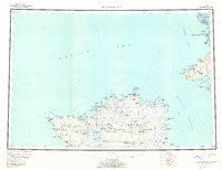
1954 Map of Nunivak Island
USGS Topo · Published 1961About this map
Nunivak Island and the surrounding Bering Sea waters are documented here during a period of mid-century federal environmental management. The landscape is defined by the Nunivak National Wildlife Refuge, which encompasses volcanic features like the Binalik Crater and the coastal Ooklik Dunes. Local settlement patterns are primarily coastal, centered on the Mekoryuk (Native Village) and numerous seasonal locations such as Kikmikshakumiut and Ahmikdoligamiut. To the east across the Etolin Strait, Nelson Island shows the community of Tanunak with its post office. The map details a complex network of subsistence sites and geographic markers, from Cape Mohican in the west to the Tachyhuimiut Lagoon in the south, reflecting the traditional land use and maritime orientation of the region's inhabitants.
Find a feature on this map
109 named features on this map. Tap any name to fly to it.
Don’t see what you’re looking for? This feature index may not catch every label — zoom into the map to look around manually.
Map Details
Editions of this 1954 Nunivak Island Map
4 editions found

Other maps of this area

1951 · Marshall
USGS Topo · 1:250,000

1951 · Kuskokwim Bay
USGS Topo · 1:250,000

1951 · Hooper Bay
USGS Topo · 1:250,000

1951 · Cape Mendenhall
USGS Topo · 1:250,000

1951 · Nunivak Island
USGS Topo · 1:250,000

1951 · Baird Inlet
USGS Topo · 1:250,000

1952 · Cape Mendenhall D-4
USGS Topo · 1:63,360

1952 · Cape Mendenhall D-3
USGS Topo · 1:63,360

1952 · Nunivak Island A-4
USGS Topo · 1:63,360

1952 · Nunivak Island A-7
USGS Topo · 1:63,360