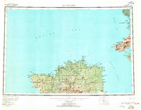
1954 Map of Nunivak Island
USGS Topo · Published 1966About this map
Nunivak Island dominates this mid-century survey of the Bering Sea coast, serving as the centerpiece for the Nunivak National Wildlife Refuge. The landscape is characterized by a series of seasonal encampments and small settlements, most notably Mekoryuk on the northern coast near Etolin Bay and Nash Harbor to the west. These sites are connected by an intricate network of waterways, including the Mekoryuk River and Antingmiut River, which drain the interior Kimikthak Hills.
Find a feature on this map
121 named features on this map. Tap any name to fly to it.
Don’t see what you’re looking for? This feature index may not catch every label — zoom into the map to look around manually.
Map Details
Editions of this 1954 Nunivak Island Map
4 editions found

Other maps of this area

1951 · Marshall
USGS Topo · 1:250,000

1951 · Kuskokwim Bay
USGS Topo · 1:250,000

1951 · Hooper Bay
USGS Topo · 1:250,000

1951 · Cape Mendenhall
USGS Topo · 1:250,000

1951 · Nunivak Island
USGS Topo · 1:250,000

1951 · Baird Inlet
USGS Topo · 1:250,000

1952 · Cape Mendenhall D-4
USGS Topo · 1:63,360

1952 · Cape Mendenhall D-3
USGS Topo · 1:63,360

1952 · Nunivak Island A-4
USGS Topo · 1:63,360

1952 · Nunivak Island A-7
USGS Topo · 1:63,360