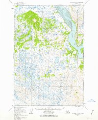
1952 Map of Nushagak Bay D-1
USGS Topo · Published 1963About this map
The Nushagak River dominates the eastern landscape of this early 1950s survey, its wide channel punctuated by distinct navigational landmarks like Lewis Point, Cross Point, and Black Point. To the west, the terrain is a dense network of thousands of small, unnamed lakes and marshy depressions, illustrating the complex hydrology of the Bristol Bay region. Evidence of human passage and seasonal residence is sparse but significant, marked by the presence of a Winter Trail running parallel to the river and a cluster of Cabins located near Black Pt. These features suggest a landscape defined by subsistence and transportation patterns that relied on the frozen interior and river access before the expansion of more permanent infrastructure.
Find a feature on this map
11 named features on this map. Tap any name to fly to it.
Don’t see what you’re looking for? This feature index may not catch every label — zoom into the map to look around manually.
Map Details
Editions of this 1952 Nushagak Bay D-1 Map
3 editions found
Other maps of this area

1945 · Nushagak Bay
USGS Topo · 1:250,000

1949 · Nushagak Bay
USGS Topo · 1:250,000

1951 · Dillingham
USGS Topo · 1:250,000

1951 · Nushagak Bay
USGS Topo · 1:250,000

1952 · Naknek
USGS Topo · 1:250,000
1952 · Nushagak Bay C-1
USGS Topo · 1:63,360

1952 · Naknek C-6
USGS Topo · 1:63,360

1952 · Dillingham A-6
USGS Topo · 1:63,360

1952 · Nushagak Bay D-1
USGS Topo · 1:63,360

1952 · Dillingham A-7
USGS Topo · 1:63,360