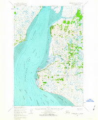
1952 Map of Nushagak Bay D-2
USGS Topo · Published 1963About this map
Kanakanak serves as a significant focal point on this coastal survey, noted specifically for the location of the US Govt Hosp overlooking the northern reaches of Nushagak Bay. The landscape is defined by its complex tidal environments and maritime infrastructure, with small settlements like Clarks Point and Ekuk positioned along the eastern shoreline. To the south, Ekuk Bluff and the Ekuk Spit mark the transition toward the deeper waters of the Ship Channel and West Channel. Further inland, the terrain is a labyrinth of water and marsh, including Clark Slough and Rolph Slough, which drain the low-lying interior. Cultural markers are few but notable, such as the Santa Claus Ch near Ekuk, illustrating the presence of established community life in this remote coastal region during the early 1950s.
Find a feature on this map
24 named features on this map. Tap any name to fly to it.
Don’t see what you’re looking for? This feature index may not catch every label — zoom into the map to look around manually.
Map Details
Editions of this 1952 Nushagak Bay D-2 Map
2 editions found
Other maps of this area

1945 · Nushagak Bay
USGS Topo · 1:250,000

1948 · Nushagak Bay D-3
USGS Topo · 1:63,360

1949 · Nushagak Bay
USGS Topo · 1:250,000

1950 · Nushagak Bay C-3
USGS Topo · 1:63,360

1951 · Dillingham
USGS Topo · 1:250,000

1951 · Nushagak Bay
USGS Topo · 1:250,000

1952 · Nushagak Bay D-3
USGS Topo · 1:63,360
1952 · Nushagak Bay C-1
USGS Topo · 1:63,360

1952 · Dillingham A-8
USGS Topo · 1:63,360

1952 · Nushagak Bay D-1
USGS Topo · 1:63,360