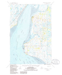
1952 Map of Nushagak Bay D-2
USGS Topo · Published 1986About this map
Nushagak Bay defines this 1950s coastal landscape, where the shifting waters of the Ship Channel and Schooner Channel dictate the rhythm of life for remote fishing settlements. On the eastern shore, the historic cannery and village sites of Nushagak, Clarks Point, and Ekuk cling to the coastline, supported by essential infrastructure like the Landing Strip and the coastal lookout at Ekuk Bluff. To the north, Kanakanak is identified as a government hospital site, serving the wider Bristol Bay region.
Find a feature on this map
25 named features on this map. Tap any name to fly to it.
Don’t see what you’re looking for? This feature index may not catch every label — zoom into the map to look around manually.
Map Details
Editions of this 1952 Nushagak Bay D-2 Map
2 editions found
Other maps of this area

1945 · Nushagak Bay
USGS Topo · 1:250,000

1948 · Nushagak Bay D-3
USGS Topo · 1:63,360

1949 · Nushagak Bay
USGS Topo · 1:250,000

1950 · Nushagak Bay C-3
USGS Topo · 1:63,360

1951 · Dillingham
USGS Topo · 1:250,000

1951 · Nushagak Bay
USGS Topo · 1:250,000

1952 · Nushagak Bay D-3
USGS Topo · 1:63,360
1952 · Nushagak Bay C-1
USGS Topo · 1:63,360

1952 · Dillingham A-8
USGS Topo · 1:63,360

1952 · Nushagak Bay D-1
USGS Topo · 1:63,360