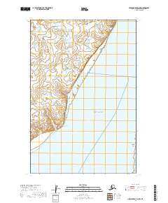
2019 Map of Nushagak Bay D-2 NW
USGS Topo · Published 2019About this map
Nushagak Bay defines the southeastern landscape of this coastal survey, where the waters meet the tidal expanse of Combine Flats. The settlement of Dillingham sits at the northern edge of the sheet, serving as a primary hub for the region. Moving south along the coastline, the terrain transitions toward Coffee Point, a notable geographical feature that juts into the bay. The map reflects a landscape defined more by its water and tidal boundaries than by extensive road infrastructure, with Antenna Road providing one of the few named land-based transit corridors. This 2019 survey documents the delicate interface between the Bristol Bay watershed and the small communities that depend on it, capturing the modern footprint of settlements situated on the edge of the vast Alaskan wilderness.
Find a feature on this map
11 named features on this map. Tap any name to fly to it.
Don’t see what you’re looking for? This feature index may not catch every label — zoom into the map to look around manually.
Map Details
Editions of this 2019 Nushagak Bay D-2 NW Map
This is the sole edition of this map. No revisions or reprints were ever made.
Other maps of this area

1945 · Nushagak Bay
USGS Topo · 1:250,000

1948 · Nushagak Bay D-3
USGS Topo · 1:63,360

1949 · Nushagak Bay
USGS Topo · 1:250,000

1951 · Dillingham
USGS Topo · 1:250,000

1951 · Nushagak Bay
USGS Topo · 1:250,000

1952 · Nushagak Bay D-3
USGS Topo · 1:63,360

1952 · Dillingham A-8
USGS Topo · 1:63,360

1952 · Dillingham A-7
USGS Topo · 1:63,360
1952 · Nushagak Bay D-2
USGS Topo · 1:63,360

1954 · Dillingham
USGS Topo · 1:250,000