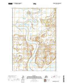
2019 Map of Nushagak Bay D-3 NE
USGS Topo · Published 2019About this map
The Snake River winds extensively through this coastal region, carving a serpentine path through the low-lying wetlands before emptying into Nushagak Bay in the southern reaches of the quadrangle. This 2019 survey documents a landscape dominated by complex hydrography and intricate drainage patterns, where the tidal influence of the bay meets the inland flow of the Snake River. The Weary River joins from the west, creating a significant confluence that defines the central geography of the area. The map illustrates a wilderness characterized by its lack of established roads or permanent settlements, showcasing the raw ecological state of the Dillingham Census Area. For researchers of Alaskan geography, this sheet provides a high-resolution look at the shifting channels and sandbars that characterize these active river systems at the edge of the Bristol Bay region.
Find a feature on this map
9 named features on this map. Tap any name to fly to it.
Don’t see what you’re looking for? This feature index may not catch every label — zoom into the map to look around manually.
Map Details
Editions of this 2019 Nushagak Bay D-3 NE Map
This is the sole edition of this map. No revisions or reprints were ever made.
Other maps of this area

1945 · Nushagak Bay
USGS Topo · 1:250,000

1948 · Nushagak Bay D-3
USGS Topo · 1:63,360

1949 · Nushagak Bay
USGS Topo · 1:250,000

1951 · Dillingham
USGS Topo · 1:250,000

1951 · Nushagak Bay
USGS Topo · 1:250,000

1952 · Nushagak Bay D-3
USGS Topo · 1:63,360

1952 · Dillingham A-8
USGS Topo · 1:63,360
1952 · Nushagak Bay D-2
USGS Topo · 1:63,360

1954 · Dillingham
USGS Topo · 1:250,000

1964 · Nushagak Bay
USGS Topo · 1:250,000