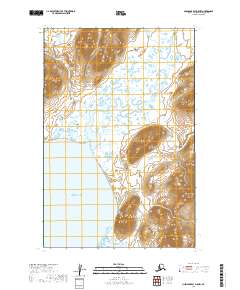
2019 Map of Nushagak Bay D-5 NW
USGS Topo · Published 2019About this map
Kanik River flows southward through the coastal wetlands of the Bristol Bay region in this 2019 survey. The landscape is defined by the expansive waters of Bristol Bay to the west and the sheltered inlet of Kulukak Bay at the southern edge of the sheet. Between these bays, the terrain consists of intricate wetland networks and low-lying coastal flats, transitioning into more defined relief as the elevation rises to the north and east. The map provides a detailed view of the natural drainage patterns and shoreline morphology before any significant human development, highlighting the pristine environment of the Dillingham Census Area where the river meets the sea.
Find a feature on this map
9 named features on this map. Tap any name to fly to it.
Don’t see what you’re looking for? This feature index may not catch every label — zoom into the map to look around manually.
Map Details
Editions of this 2019 Nushagak Bay D-5 NW Map
This is the sole edition of this map. No revisions or reprints were ever made.
Other maps of this area

1945 · Nushagak Bay
USGS Topo · 1:250,000

1949 · Nushagak Bay
USGS Topo · 1:250,000

1950 · Nushagak Bay D-5
USGS Topo · 1:63,360

1950 · Nushagak Bay D-6
USGS Topo · 1:63,360

1951 · Goodnews
USGS Topo · 1:250,000

1951 · Nushagak Bay
USGS Topo · 1:250,000

1964 · Nushagak Bay
USGS Topo · 1:250,000

1979 · Goodnews Bay
USGS Topo · 1:250,000
1979 · Goodnews Bay A-2
USGS Topo · 1:63,360
2019 · Nushagak Bay D-6 NE
USGS Topo · 1:25,000