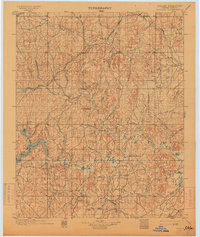
1901 Map of Nuyaka
USGS Topo · Published 1914About this map
The Nuyaka Mission stands as a central landmark in the Creek Nation territory of Indian Territory during the late nineteenth century. This survey, conducted just prior to Oklahoma statehood, reveals a landscape defined by the winding course of the Deep Fork Canadian River and its numerous tributaries. Early rail commerce is evident through the path of the St. Louis and San Francisco Railroad, which connects emerging settlements like Bristow, Kellyville, and Sapulpa. The map captures a critical transition period as the tribal lands were being partitioned and surveyed. Smaller outposts and gathering places such as Tuskegee, Smiths Store, and Okfuskee are documented alongside natural features like Polecat Creek and Tiger Creek, providing a detailed look at the region's geography before the turn of the century development changed the rural character of the area.
Find a feature on this map
64 named features on this map. Tap any name to fly to it.
Don’t see what you’re looking for? This feature index may not catch every label — zoom into the map to look around manually.
Map Details
Editions of this 1901 Nuyaka Map
4 editions found
Other maps of this area

1896 · Seminole and Prague
USGS Topo · 1:125,000

1896 · Okmulgee
USGS Topo · 1:125,000

1900 · Canadian
USGS Topo · 1:125,000

1900 · Wewoka
USGS Topo · 1:125,000

1900 · Okmulgee
USGS Topo · 1:125,000

1901 · Claremore
USGS Topo · 1:125,000

1901 · Nuyaka
USGS Topo · 1:125,000

1912 · Hominy
USGS Topo · 1:125,000

1914 · Kiefer
USGS Topo · 1:62,500

1914 · Claremore
USGS Topo · 1:125,000