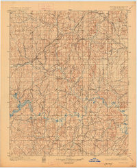
1901 Map of Nuyaka
USGS Topo · Published 1925About this map
Nuyaka Mission serves as a cultural and geographic anchor in this 1890s survey of the Creek Nation, situated within the drainage basin of the Deep Fork and Salt Creek. The landscape is a network of small family-named watercourses like Frank Henry Creek and McKenson Cr., reflecting the early tribal and settler geography of the Indian Territory before Oklahoma statehood. Transportation and commerce are defined by the St. Louis and San Francisco R. R., which connects the growing communities of Sapulpa, Kellyville, and Bristow.
Find a feature on this map
53 named features on this map. Tap any name to fly to it.
Don’t see what you’re looking for? This feature index may not catch every label — zoom into the map to look around manually.
Map Details
Editions of this 1901 Nuyaka Map
4 editions found
Other maps of this area

1896 · Seminole and Prague
USGS Topo · 1:125,000

1896 · Okmulgee
USGS Topo · 1:125,000

1900 · Canadian
USGS Topo · 1:125,000

1900 · Wewoka
USGS Topo · 1:125,000

1900 · Okmulgee
USGS Topo · 1:125,000

1901 · Claremore
USGS Topo · 1:125,000

1901 · Nuyaka
USGS Topo · 1:125,000

1912 · Hominy
USGS Topo · 1:125,000

1914 · Kiefer
USGS Topo · 1:62,500

1914 · Claremore
USGS Topo · 1:125,000