
1969 Map of O'Donnell
USGS Topo · Published 1971About this map
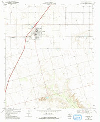
O'Donnell anchors this West Texas landscape at the border of Lynn and Dawson counties, where the high plains begin to break toward the drainage of T I F Draw. The 1969 survey reveals a community deeply connected to the Atchison Topeka and Santa Fe railroad, which cuts a straight line through the territory. Local life is evidenced by the Rodeo Ground and the nearby O'Donnell Cem, while the regional economy is represented by scattered resource extraction, including several Oil Wells and a Gravel Pit. Further south, the terrain shifts into more varied elevation near the Caprock Ranch, where the presence of a Spring and multiple Wells suggests the critical importance of water management on the Staked Plains. A prominent Radio Tower and a large Pipeline crossing the quadrangle reflect the infrastructure developments of the late 1960s.
Find a feature on this map
18 named features on this map. Tap any name to fly to it.
Don’t see what you’re looking for? This feature index may not catch every label — zoom into the map to look around manually.
Map Details
Editions of this 1969 O'Donnell Map
2 editions found
Other maps of this area

1954 · Lubbock
USGS Topo · 1:250,000

1954 · Big Spring
USGS Topo · 1:250,000

1958 · Big Spring
USGS Topo · 1:250,000

1968 · Lamesa North
USGS Topo · 1:24,000

1968 · Hancock
USGS Topo · 1:24,000

1969 · Skeen Lake
USGS Topo · 1:24,000

1969 · Gooch Lake
USGS Topo · 1:24,000
1969 · Tahoka SW
USGS Topo · 1:24,000

1969 · Indian Canyon
USGS Topo · 1:24,000
1970 · Draw
USGS Topo · 1:24,000