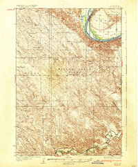
1937 Map of Oahe
USGS Topo · Published 1937About this map
The Missouri River cuts through this Central South Dakota landscape, defining the border between Stanley and Hughes counties. The alluvial plain of Peoria Bottom sits opposite the rugged breaks of the western shore, where family-run operations like Madison Ranch and Huckfeldt Ranch were established along prominent landforms such as Anderson Ridge. This mid-1930s landscape is dotted with rural educational centers, including Riverview Sch and Willow Creek Sch, which served the scattered ranching community before the era of school consolidation.
Find a feature on this map
29 named features on this map. Tap any name to fly to it.
Don’t see what you’re looking for? This feature index may not catch every label — zoom into the map to look around manually.
Map Details
Editions of this 1937 Oahe Map
3 editions found
Other maps of this area

1924 · Pierre
USGS Topo · 1:62,500

1937 · Oahe
USGS Topo · 1:62,500

1951 · Van Metre
USGS Topo · 1:24,000

1953 · Teton
USGS Topo · 1:24,000

1953 · Oahe SW
USGS Topo · 1:24,000

1953 · Pierre SW
USGS Topo · 1:24,000

1953 · Wendte
USGS Topo · 1:24,000

1953 · Wendte NE
USGS Topo · 1:24,000

1953 · Pierre 3 NW
USGS Topo · 1:24,000

1954 · Pierre
USGS Topo · 1:250,000