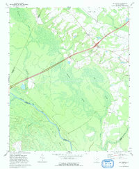
1972 Map of Oak Grove
USGS Topo · Published 1992About this map
Pocosin Swamp and Gum Swamp dominate the low-lying interior of this 1970s landscape, illustrating the intricate drainage patterns where the Great Pee Dee River and Black Cr converge. The settlement of Oak Grove serves as a small upland anchor, surrounded by essential community markers such as Bethesda Ch and Mill Creek Ch. The presence of an Old Railroad Grade cutting through the marshy terrain reflects the historical importance of timber and agricultural transport in this riverine region.
Find a feature on this map
24 named features on this map. Tap any name to fly to it.
Don’t see what you’re looking for? This feature index may not catch every label — zoom into the map to look around manually.
Map Details
Editions of this 1972 Oak Grove Map
2 editions found
Other maps of this area

1940 · Florence East
USGS Topo · 1:62,500

1943 · Gum Swamp
USGS Topo · 1:62,500

1945 · Florence East
USGS Topo · 1:62,500

1947 · Marion
USGS Topo · 1:24,000

1953 · Florence
USGS Topo · 1:250,000

1954 · Florence
USGS Topo · 1:250,000

1960 · Latta
USGS Topo · 1:24,000

1960 · Dillon West
USGS Topo · 1:24,000

1972 · Drake
USGS Topo · 1:24,000
1972 · Oak Grove
USGS Topo · 1:24,000