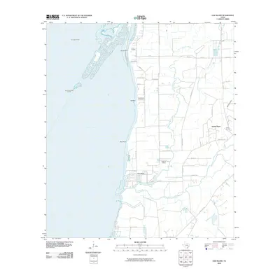
2010 Map of Oak Island
USGS Topo · Published 2010About this map
Trinity Bay dominates the western half of this coastal landscape, where the land meets the water at distinctive landmarks like Round Point, Ash Point, and Black Point. The settlement of Oak Island sits near the mouth of the West Fork Double Bayou, a primary waterway that snakes through the marshy terrain alongside the East Fork Double Bayou. This area is defined by its coastal industries, with the Trinity Bay Oil Field and North Fishers Reef Gas Field situated offshore, while the Double Bayou Gas Field occupies the terrestrial region to the north.
Find a feature on this map
40 named features on this map. Tap any name to fly to it.
Don’t see what you’re looking for? This feature index may not catch every label — zoom into the map to look around manually.
Map Details
Editions of this 2010 Oak Island Map
This is the sole edition of this map. No revisions or reprints were ever made.
Other maps of this area

1931 · Frozen Point
USGS Topo · 1:24,000

1933 · Frozen Point
USGS Topo · 1:31,680

1933 · Whites Lake
USGS Topo · 1:31,680

1933 · Smith Point
USGS Topo · 1:31,680

1942 · Anahuac
USGS Topo · 1:24,000

1943 · West of Eagle
USGS Topo · 1:31,680

1943 · Frozen Point
USGS Topo · 1:24,000
1943 · Smith Point
USGS Topo · 1:24,000
1943 · Lake Stephenson
USGS Topo · 1:24,000

1950 · Houston
USGS Topo · 1:250,000