1943 Map of Smith Point
USGS Topo · Published 1952About this map
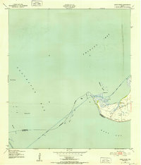
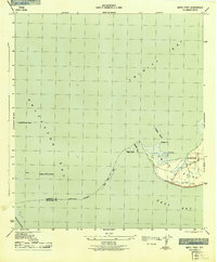
Smith Point serves as the focal point for this coastal survey, where the convergence of Trinity Bay, Galveston Bay, and East Bay dictates the geography of Chambers County. During the early 1940s, the maritime landscape was defined by essential navigation markers and industrial expansion, evidenced by the presence of oil wells and numerous lights protecting the Trinity River Channel and the Houston Ship Channel. Small landforms like the Vingt-et-un Islands and Nigger Island dot the waters near Morgan Point, while the interior of the point shows a pattern of early utility development with several windmills and a dock serving the local shoreline. The map also records the approximate boundary between Chambers and Galveston counties as it cuts through Red Fish Bar, illustrating the complex administrative lines across these tidal flats.
Find a feature on this map
23 named features on this map. Tap any name to fly to it.
Don’t see what you’re looking for? This feature index may not catch every label — zoom into the map to look around manually.
Map Details
Editions of this 1943 Smith Point Map
3 editions found
Historical Maps of Texas City Through Time
46 maps found

1916 Morgan Point
Chambers County, TX

1919 Morgan Point
Chambers County, TX

1931 Frozen Point
Chambers County, TX

1931 High Island
Chambers County, TX

1932 Clifton By The Sea
Chambers County, TX

1933 Frozen Point
Chambers County, TX

1933 Smith Point
Chambers County, TX

1933 Whites Lake
Chambers County, TX

1943 Clifton By The Sea
Chambers County, TX

1943 Frozen Point
Chambers County, TX

1943 High Island
Chambers County, TX

1943 Lake Stephenson
Chambers County, TX

1943 Morgan Point
Chambers County, TX

1943 Sea Breeze
Chambers County, TX

1943 Smith Point
Chambers County, TX

1943 West of Eagle
Chambers County, TX

1945 Sea Breeze
Chambers County, TX

1956 Morgans Point
Chambers County, TX

1961 Lake Stephenson
Chambers County, TX

1961 Monroe City
Chambers County, TX

1961 Oyster Bayou
Chambers County, TX

1961 Smith Point
Chambers County, TX

1961 Umbrella Point
Chambers County, TX

1962 Frozen Point
Chambers County, TX

1962 High Island
Chambers County, TX

1962 Stanolind Reservoir
Chambers County, TX

1982 Morgans Point
Chambers County, TX

1993 Morgans Point
Chambers County, TX

1993 Smith Point
Chambers County, TX

1994 Frozen Point
Chambers County, TX

1994 High Island
Chambers County, TX

1994 Lake Stephenson
Chambers County, TX

1994 Monroe City
Chambers County, TX

1994 Oyster Bayou
Chambers County, TX

1994 Stanolind Reservoir
Chambers County, TX

1994 Umbrella Point
Chambers County, TX

1995 Morgans Point
Chambers County, TX

2022 Lake Stephenson
Chambers County, TX

2022 Monroe City
Chambers County, TX

2022 Morgans Point
Chambers County, TX

2022 Smith Point
Chambers County, TX

2022 Umbrella Point
Chambers County, TX

2025 Frozen Point
Chambers County, TX

2025 High Island
Chambers County, TX

2025 Oyster Bayou
Chambers County, TX

2025 Stanolind Reservoir
Chambers County, TX