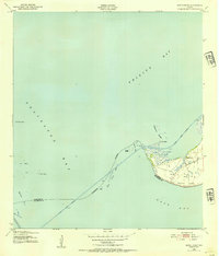
1943 Map of Smith Point
USGS Topo · Published 1954About this map
Smith Point projects into the confluence of Trinity Bay, Galveston Bay, and East Bay in this coastal survey based on 1940s aerial photography. The landscape is defined by the critical maritime infrastructure of the Texas coast, centered on the Trinity River Channel and the Houston Ship Channel. Along the marshy coastline, the small settlement of Smith Point is surrounded by a network of windmills and early oil wells, signaling the burgeoning petroleum industry that would come to dominate the region. The map captures the intricate geography of the shoreline before significant modern alteration, featuring the Vingt-et-un Islands and various coastal landmarks like Morgan Point and Trout Pt. This study offers a clear view of the mid-century relationship between small-scale ranching and the industrial maritime traffic moving through the bay system.
Find a feature on this map
20 named features on this map. Tap any name to fly to it.
Don’t see what you’re looking for? This feature index may not catch every label — zoom into the map to look around manually.
Map Details
Editions of this 1943 Smith Point Map
3 editions found
Other maps of this area

1916 · Morgan Point
USGS Topo · 1:24,000

1919 · Morgan Point
USGS Topo · 1:31,680

1929 · Texas City
USGS Topo · 1:24,000

1931 · Flake
USGS Topo · 1:24,000

1932 · Clifton By The Sea
USGS Topo · 1:31,680

1932 · Texas City
USGS Topo · 1:31,680

1932 · Bolivar Point
USGS Topo · 1:24,000

1933 · Whites Lake
USGS Topo · 1:31,680

1933 · Smith Point
USGS Topo · 1:31,680

1933 · Bolivar Point
USGS Topo · 1:31,680