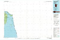
1985 Map of Oak Island
USGS Topo · Published 1985About this map
The Northwest Angle State Forest dominates this unique 1980s landscape, where the northernmost point of the contiguous United States meets the international border. This survey details the intricate geography of the Lake of the Woods, showing the complex boundary between Minnesota and Ontario as it threads through Sturgeon Channel and past Garden Island. The map highlights the tribal lands of the Red Lake Indian Res and a cluster of remote islands including Penasse Island, Little Oak Island, and Crowduck Island. Navigational points like Northwest Angle Inlet and Harrison Creek illustrate the water-dependent lifestyle of this isolated enclave. The planimetric detail records the exact position of landmarks such as Sugar Point and Driftwood Point during a period of modern mapping and boundary refinement.
Find a feature on this map
35 named features on this map. Tap any name to fly to it.
Don’t see what you’re looking for? This feature index may not catch every label — zoom into the map to look around manually.
Map Details
Editions of this 1985 Oak Island Map
2 editions found
Other maps of this area

1918 · Buffalo Bay
USGS Topo · 1:62,500

1918 · Roosevelt
USGS Topo · 1:62,500
1918 · Oak Island
USGS Topo · 1:62,500

1918 · Williams
USGS Topo · 1:62,500

1919 · Canada
USGS Topo · 1:62,500

1943 · Roosevelt
USGS Topo · 1:62,500

1954 · Roseau
USGS Topo · 1:250,000

1954 · International Falls
USGS Topo · 1:250,000

1957 · Roseau
USGS Topo · 1:250,000

1957 · International Falls
USGS Topo · 1:250,000