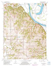
1961 Map of Oak Mills
USGS Topo · Published 1983About this map
Missouri River loops and backwaters define the border between Kansas and Missouri in this early 1960s survey, showing a landscape shaped by both the river and the Pacific railroad line. The map highlights the rural communities of Oak Mills and Dalbey perched near the river bluffs, while further inland, the agricultural character of Walnut and Kickapoo townships is marked by numerous country churches and cemeteries. Local history is deeply embedded in features like Mt Gillian Ch and Round Prairie Ch, which served as anchors for the surrounding farmsteads. Significant water features such as Bean Lake and Little Bean Lake occupy the floodplains in Marshall, illustrating the complex hydrology of the river bottom before later 20th-century developments. These oxbows and sloughs, including Cottonwood Slough, reflect the shifting nature of the state line over time.
Find a feature on this map
36 named features on this map. Tap any name to fly to it.
Don’t see what you’re looking for? This feature index may not catch every label — zoom into the map to look around manually.
Map Details
Editions of this 1961 Oak Mills Map
4 editions found
Other maps of this area

1885 · Atchison
USGS Topo · 1:125,000

1886 · Oskaloosa
USGS Topo · 1:125,000

1888 · Oskaloosa
USGS Topo · 1:125,000

1888 · Atchison
USGS Topo · 1:125,000

1890 · Kansas City
USGS Topo · 1:125,000

1893 · Atchison
USGS Topo · 1:125,000

1894 · Kansas City
USGS Topo · 1:125,000

1894 · Oskaloosa
USGS Topo · 1:125,000

1910 · Leavenworth
USGS Topo · 1:62,500

1926 · Atchison
USGS Topo · 1:62,500